Giant steps taken to recalculate height of Qomolangma
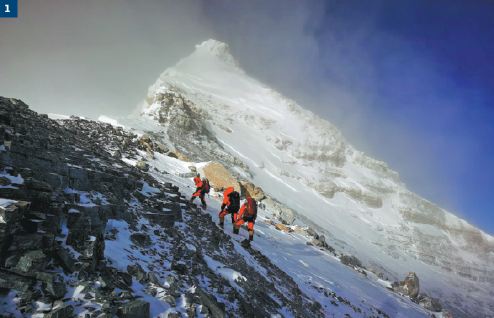
Surveyors set out from a camp at 8,300 meters on May 27, aiming for the summit of Qomolangma. TASHI TSERING/XINHUA
On May 27, a strong, cold wind swept across the summit of Qomolangma, known in the West as Mount Everest. The air temperature was-30 C.Eight mountaineers reached the summit at 11 am and began conducting a survey that attracted the attention of a large part of the Chinese population-precisely determining the height of the world's highest mountain.
The team remained at the summit, at an altitude of about 8,840 meters, for two-and-a-half hours-a record for Chinese climbers. They erected a surveyor's beacon, an important measuring device, and installed an antenna for the Beidou Navigation Satellite System on the snow-covered peak, which measures less than 20 square meters. Meanwhile, observations were conducted from six points lower down the mountain.
It took six months of hard work to prepare for those two-and-a-half hours of data collection for scientific research. The program officially began on April 30, when the Ministry of Natural Resources announced the start of the remeasuring process. The project was undertaken in conjunction with the Ministry of Foreign Affairs, the General Administration of Sports of China and the government of the Tibet autonomous region.
"As this year marks the 60th anniversary of the first successful expedition (by Chinese mountaineers) to Qomolangma from the Chinese side and the 45th anniversary of China's first measurement of its height, the remeasurement carries great historical importance," the ministry said on its Sina Weibo account.
The mission was undertaken by the 1st Geodetic Surveying Brigade, under the ministry's jurisdiction, and members of the China Mountaineering Team, said Wang Yongfeng, deputy head of the Mountaineering Sports Management Center at the sports administration.
On May 6, a team of 30 surveyors and mountaineers started out from North Base Camp in Tibet.
It took nearly a month to finish the survey, which was one of the most challenging ever conducted on the mountain. The results will not be announced until a series of complex calculations have been completed in the coming months.
According to the ministry, innovations in techniques and equipment included the use of the BeiDou-3 Navigation Satellite System, Chinesemade surveying equipment, a gravimeter carried by plane and 3D interactive virtual reality.
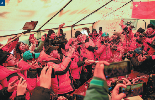
Team members at North Base Camp drink champagne to celebrate the successful ascent. PURBU ZHAXI/XINHUA
A perplexing question
The desire to explore the world's extremities has driven countless adventurers to test their courage, energy and skill, and Qomolangma definitely ranks high on the wish list.
The question of the mountain's height has perplexed Chinese scientists and administrators for hundreds of years, but regular changes in geological structure and improvements in measuring equipment and technology have produced a range of answers.
Qomolangma straddles the China-Nepal border, with its northern section located in Shigatse, Tibet.
Chinese scientists conducted the first survey of the mountain more than 300 years ago, during the Qing Dynasty (1644-1911).
Since the founding of the People's Republic of China in 1949, surveyors had conducted six other rounds of measurement and scientific research.
However, only the heights calculated after surveys conducted in 1975 and 2005 were released, coming in at 8,848.13 meters and 8,844.43 meters respectively.
Given the huge amounts of money and people involved, why must the mountain be measured so often?
"Like parents who check the health of their children in various ways, including by measuring their height, scientists measure the height of the world's highest mountains to learn more about the earth and collect geoinformation," said Chen Junyong, a geologist and member of the Chinese Academy of Sciences.
He noted that Qomolangma is located at the point where the Eurasian and Indian tectonic plates meet, which makes the mountain the perfect window for observing crustal movement. Changes in the peak's height could indicate whether the plates are heading toward or away from each other.
Qomolangma emerged from the oceans 38 million years ago as a result of the two plates colliding, according to Chen.
"Crustal movement affects the geological structure, including the mountain's height. As the plates move, the height-which is affected by geological activity, such as earthquakes-changes," he said.
Dang Yamin, director of the Institute of Geodesy and Geodynamics at the Chinese Academy of Surveying and Mapping, used the magnitude 7.9 earthquake that struck Nepal in 2015 as an example, noting that it caused permanent changes in the Earth's surface and may have affected the height of Qomolangma.
"Scientists from other countries measured the height following the earthquake via various methods such as GPS. However, the most reliable measurement cannot be calculated unless professional surveys are conducted on the site," Dang said.
"The answer provided by last month's project will be the most reliable."
As leader of the technical coordination group, Dang said the survey team noted the condition of the snow and ice at the summit that may indicate imminent climate change on the Tibet-Qinghai Plateau.
"That's why measuring Qomolangma's height is so significant. Put to good use, it could benefit mankind," he said.
Calculations
According to Liu Zhanke, deputy chief engineer of this year's survey, mountains are measured with basic trigonometry.
The technique, which has been used for hundreds of years, helped teams under the guidance of George Everest (surveyor general of India 1830-43) to calculate the height of Qomolangma in the 1840s.
To calculate the elevation of a mountain, scientists measure the distance between two points on the ground and then measure the angles between the top of the mountain and each point. With two angles and one side of a triangle, trigonometry reveals the lengths of the other sides, and thereby, the height of the triangle (the mountain), Liu said.
To make the measurements, surveyors must identify a horizontal surface by using a base level. In China, that is the level of the Yellow Sea off Qingdao in the eastern province of Shandong, more than 4,000 kilometers from Qomolangma.
"Sea level changes in different parts of the world due to the influence of tidal forces. So, every country has a legally recognized sea level. The current level of the Yellow Sea was calculated based on continuous observation of changes over 19 years, which is longer than an astronomical tidal period," said Jiang Tao, associate researcher at the academy of surveying and mapping and a member of the advisory panel for this year's survey.
Having confirmed the results of previous sea level measurements, the scientists passed on the data to teams of surveyors in Dingri county, Tibet.
"Once the surveyor's beacon had been placed on the summit, surveyors at stations around the summit measured the distance from the six points to the beacon, which meant at least six triangles could be calculated to determine the mountain's height," Jiang said.
In 1975, a surveyor's beacon was placed on Qomolangma's summit for the first time by a team of Chinese mountaineers.
That allowed surveyors at nine observation stations near the mountain to calculate that it was 8,848.13 meters high-the first time China had officially announced the height.
In the two large-scale comprehensive scientific surveys that followed, in 2005 and May, beaconsabout 3 meters tall and 5 kilograms in weigh-were carried to the top, Jiang said.
"Of course, one measurement could be wrong, so surveyors calculated the dimensions of the mountain from many stations at the base, averaging out the heights calculated with many, many triangles," he said.
Nowadays, surveying and mapping projects are aided by technological developments. In addition to the BeiDou-3 Navigation Satellite System, other modern instruments (mostly made in China) also played a role, such as a gravimeter to measure gravity, a radar to calculate snow depth, and meteorological instruments to assess the weather.
High standards
"China's surveying and mapping technology has been of international standard since the 1970s. China is developing more and better surveying equipment, some of which was used during this year's survey, such as the BeiDou-3 Navigation Satellite System," said Dang from the academy of surveying and mapping.
He added that the gravity survey was the highest ever taken, thus setting a world record. The previous record was set by surveyors Ren Xiubo and Bai Huagang in 2005 at an altitude of 7,790 meters.
Li Guopeng, from the 1st Geodetic Surveying Brigade, said: "The gravity survey bridges traditional and modern measurement technologies. With it, scientists can better analyze the data collected via the two measurements and get an even more precise result."
As the force of gravity weakens slightly the higher one rises above sea level, Li said very sensitive measurements of the actual gravitational field on or near Qomolangma can be used to calculate the location of the geoid-a model of global mean sea level that is used to measure surface elevation-below the summit.
According to Jiang, from the academy of surveying and mapping, there was no previous record of ground gravity data from the summit of Qomolangma.
"But the survey in May has filled in the blank, which will not only contribute to the calculation of the mountain's height, but also help us to understand the tectonic movements that lead to earthquakes," he said.
Jiang said the gravity measuring equipment used in last month's survey was made in China, and as it only weighed about 15 kg it was carried to the summit in a backpack.
"This domestically made device is smaller and lighter than imported units; the design perfectly matched the survey this time," he said.
In addition to BeiDou-3 and the gravity survey equipment, he listed other Chinese-made devices used in the survey, including a radar to measure snow depth and a long-distance range finder.
"Chinese surveying and mapping technology is currently among the best in the world. Therefore, the survey conducted by the country's leading experts in the field will be reliable and authoritative," he said.
Extreme conditions
While thousands of climbers have reached the summit of Qomolangma since it was first conquered in 1953, the northern route used by the Chinese survey party is regarded as one of the most difficult approaches to the top.
The team members had to contend with low oxygen levels, biting cold and extreme winds as they carried the surveying equipment, which weighed about 30 kilograms in total, and oxygen cylinders.
As technology improves, satellites, radars and gravity measuring technologies are increasingly being used to determine accurate figures. However, someone still has to carry the instruments to the summit.
"The surveyor's beacon had to be carried to the summit by hand," said Zhang Qingtao, deputy leader of the survey team.
Scaling Qomolangma is no easy task. The average air temperature at the summit is -30 C, four degrees lower than in Antarctica. The snow is often very deep, and hurricane-force winds blow constantly. The team members started training in January to cope with the extreme conditions.
Li, the head of the team, said professional surveyors are adept at using the advanced equipment, so the data they obtain are more reliable, scientific and convincing.
He added that the surveyors' experience with the equipment helped to limit the amount of time spent at the summit, reducing their exposure to the frigid temperatures and oxygenstarved environment.
On May 18, the Ministry of Natural Resources announced that a team of 12 was expected to reach the summit two days later. However, three team members had no experience of climbing at above 8,000 meters.
A day later, the National Meteorological Center warned that Cyclone Amphan was expected to make landfall in India and Bengal on May 20, bringing heavy snow to the Qinghai-Tibet Plateau, which could affect conditions on Qomolangma.
The 12-man team attempted to reach the summit twice, on May 12 and 22, but was beaten by adverse weather both times.
After concerns were expressed about the less-experienced members of the team, the number was reduced to eight, all seasoned high-altitude climbers.
When the team reached the summit, they reverted to their professional identities as surveyors.
Phurbu, an avid climber who has reached the summit 12 times, went without supplementary oxygen for more than 110 minutes so he could work more efficiently.
"When we were on the summit, my duties were to fix the beacon, check satellite signals and wire the surveying equipment," he said.
"Time was precious and the work was so important that I removed my oxygen mask so I could see the equipment more clearly."
Dang said that although technology assists the surveying and mapping work, modern instruments are not currently accurate enough to replace traditional techniques, which provide much more precise data.
Meanwhile, the unstable airflow, fierce winds and low temperatures, mean that drones and remote sensing satellites do not yet work at the summit of Qomolangma.
Dang said the remote sensing satellite can only produce measurements accurate to about 2 meters, while manual surveys can reach an accuracy level of about 1 centimeter.
However, he noted that the current development rate of surveying drones means they will be used more frequently in the future, which may result in fewer surveyors scaling the mountain to check its height.
yangwanli@chinadaily.com.cn